
Korsan Koyu – Gelidonya Feneri / Korsan (Pirate’s) Bay – Gelidonia Lighthouse
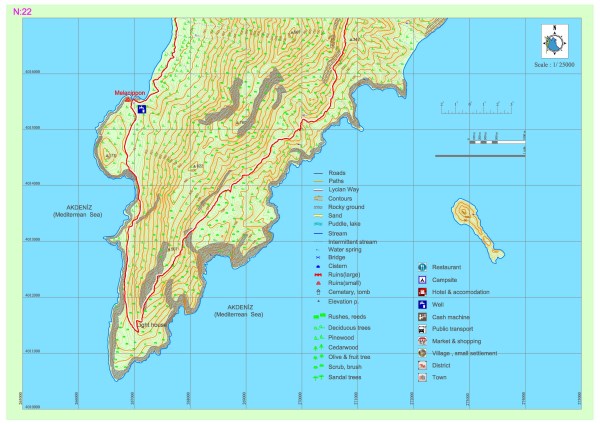
At this part of the Lycian road, the path moves from the settlement of Karaöz to the south and continues via a dirt road and parts left from this road at the end part of the peninsula. The path then ascends within the forest and arrives at a slope viewing Cape Gelidonia and the Gelidonia Lighthouse.
The path ascends a little more by following the slope of the hill, after which it starts to decline within the forest. The path then continues towards Adrasan in parallel fashion to the coast, which provides the travelers with a view of the sea for a while. Within Section 22, the only source of potable water is the fountain that is located at the ancient settlement which is indicated as Melanippe (Korsan [Pirate’s] Bay).
MELANIPPE
The ancient city of Melanippe is a small coastal settlement which was under dominance of Gagai from the Hellenistic period and which is located on a peninsula that is 3 kilometers from the Karaöz Bay, Mavikent Town, Kumluca District, Antalya Province. The city is significant due to its position as a natural harbor that served the settlements around it as well. Cape Gelidonia, which is very near Melanippe, was the sea border between the Persians and the Greeks after the Peace of Callias treaty in 449 BC.


It is understood via Hecataeus of Miletus the geographer, who wrote around 1500 BC, that the city was established in the archaic period as a Greek colony. The city’s name itself is Greek, derived from the Greek words melas (black) and hippos (horse). The city survived during the middle ages sometimes under the name of Karaozi and sometimes under the name of Sanetus Stephanus/Agios Stephanos. It is presumed that this latter name was given to the city due to a church with three naves, of which the foundations still stand and which was built for Saint Stephanos on a plain at northwest of the harbor.
It is understood from the ship and boat depicting graffiti that have been inscribed on the plaster of its outer walls that this church is one that has served sailors. The city, which has been surrounded by walls on three sides, can be entered from the south of the harbor, via a path that leads uphill towards west. The entrance gate is besides a rectangular tower built outside the southern walls. This part of the walls, which are presumed to have been built in the 5th century, are well preserved.
The surviving buildings within the city are at north. The lower floors of the domiciles, which are generally two-storey buildings, have vaulted cisterns. All of the structures in the settlement area belong to the Byzantine period. Early period building stones have been used in these structures. The quite narrow streets are not any wider than two meters.
The basilica with three naves, which is built on the highest point of the hill, is smaller than the Agios Stephanos Basilica. The olive processing workshops that have been carved into the rock bottom in the middle part of the settlement, south of the basilica, indicate that olive oil was produced here in the past.
The structures to which the remains around the harbor belong are presumed to have served functions regarding the harbor. Even though some sources cite that there is a temple for Athena in the city, the existing remains exhibit no sign of such a temple. Within the bay, some undersea tombs and urns were found.