
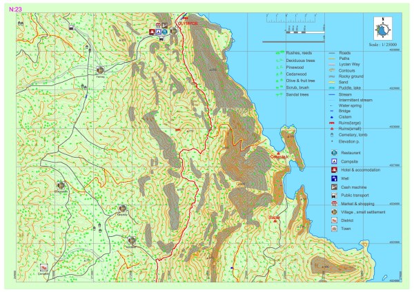
Adrasan – Olympos
The path which comes from Adrasan, goes through the forest and climbs to the northern slopes of Musa Mountain from within the valley. It starts to descend from around the settlement of Olympus. After progressing through a landscape of sandalwood forest and continuing paralele to the creek basin at the side of the valley, the path reaches the coastal settlement of Olympus and the archaeological settlement of Corycus. There are no food or water resources along the path. The only location on which needs for food, water, etc. can be met is the coastal settlement of Olympus.
GENOESE BAY
While Genoese Bay is referred to as a safe haven in the marine guides of 14th century, the bay which is marked in the Map of Piri Reis is defined as on of the most important harbors of Lycia by some of the 19th century travelers.
On the eastern slope of the valley, at a position where the bay can be best viewed, there are the remains of a two-storey building which is presumed to have been built to aid sailors that try to evade storms in the open sea during the Byzantine and Roman period. Since the region was especially prominent in the middle ages for seafaring and the Venetian, Genoese and Rhodian knights were active on the coasts of this region, it is presumed that the Genoese Bay was a significant haven during the 15th century and received its name during the same.


SAZAK BAY
Sazak Bay, which has been protected from all kinds of weather phenomena except for the easterly wind from the ancient period until today, has been one of the most important havens of the region for sailors. About 700 to 750 meters inland, on a hill that extends from east to west, there is a small farm settlement consisting of 5 to 6 structures and olive processing workshops and of which the walls can be seen at ground level. The findings on the surface indicate that the farm was active during the Roman period. On the south of the settlement, there is a tomb with a pyramidal lid and a sarcophagus which is carved out of the rock bottom.
OLYMPUS
Olympus, which is located at the east of Lycia, has been called “High Mountain or Great Mountain” in the old Anatolian languages. The precise establishment date of the city is unknown. Within the Lycian League, Olympus was one of the three privileged cities that had three votes and at times, the League leader (Lychiarch) was a citizen of Olympus. In 80 BC, the city was conquered by pirates. Zeniketes, who was one of the most famous Cilician pirates, resided in a fortress near Olympus. The Roman fleet, which arrived in order to eliminate the pirates in the region, won the sea battle in 78 BC and leveled the famous fortress of Zeniketes to the ground. The city, which regained its former significance during the Roman Empire period, was visited by Emperor Hadrian during its second journey through Anatolia (129-131). During this period, the city was renamed as Hadrianopolis in honor of this visit. As with all other coastal cities, natural disasters after the 6th century and plagues that kept recurring between 542 and the 8th century caused for the population of Olympus to decrease and for its people to migrate to highlands.
Christianity arrived early at Olympus. In the course of the crusades during the 11th and 12th centuries, the city was invaded by Venetian, Genoese and Rhodian knights and during this period, the acropolis and the two fortresses on the slope at its south were built, in addition to some people settling in the buildings within the city. In the 15th century, just like the entire Tekeli (Teke) peninsula, Olympus became Ottoman territory as well. The fact that there were no settling during this period enabled for the middle age texture of the city to be preserved on a large scale and survive until today. From the 18th century to the early 20th century, the city was used as winter quarters by the Yuruks. Olympus is a city in which traces belonging to all the settlements of classical, Hellenistic, Roman and Byzantine periods are exhibited. The most populated area of the city was the region around two sides of the Göksü Creek. During the ancient period, the north and south sides of the city were connected via a bridge with three arches. The remains of the walls that extend on both sides of the creek can be traced back to the Hellenistic period. Monumental public structures belonging to the Roman period are at the south of the city while structures from the Byzantine period are at the north.
The acropolis of the city is at an altitude of approximately 50 meters from sea level. The part of the acropolis which is at sea level at the beginning of the Harbor Street hosts the Harbor Monumental Tombs. The most original of these tombs is the sarcophagus of Captain Eudemos, on which there is a relief of a ship and some inscriptions.
The western skirts of the acropolis host the Byzantine Bathhouse, Chapel and the ruins of a mill built in the 19th century upon the Harbor Street. The water channel of the mill was built by using wall remains from the Byzantine period. The tomb of the Lyciarch and the remains of a structure with mosaics which is presumed to have been used around 570 are located on the northeast of the channel which is also used as a path. The structure is ornamented with cross patterns. The only survivivng remains of the temple, which collapsed due to natural disasters and turned into a marsh, is the monumental gate. This gate is surrounded by churches, chapels and remains of other structures.
Upon moving west, remains of structures of which the second and third floors still stand and the layout forms streets can be encountered parallel to the Harbor Street. The Northern Necropolis, which consists of single, double or triple tombs is on the west of the structure remains. Structures such as the Theatre, Bathhouse and the Harbor (Large) Basilica belonging to the early Christianity period that are on the south of the city are the most important public structures of the Roman period. It is presumed that the cavea and stage buildings of the theatre were damaged by the earthquake in 141. The tombs in the Necropolis area on the west of the theatre and the southern side of the Olympus creek are more similar to the tombs of the Cilicia region than those of the Lycia region.
It is presumed that the Hellenistic period settlement of the city of Olympus is the settlement that is referred to as the Plateau Hill and that the city was moved to the coast during the Roman period. Entrance to the city settlement on the Plateau Hill, which was at an altitude of 700 meters above sea level, was through the northwestern gate. This part of the settlement was surrounded by defense walls built out of stone blocks. There is a tower on the east of the entrance gate. Since the southwestern area consists of rocky terrain, it was not found essential for any city walls to be built here. The street that starts from the entrance gate reaches the Agora. East and west of the Agora was used as residential areas and there are many public structures and cisterns along the road. Remains of one of these structures, namely the temple belonging to the Hellenistic period, exhibits high quality stonemasonry work. The southeast of the settlement hosts structural remains belonging to the Byzantine period.