
Category (en-gb)
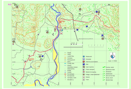
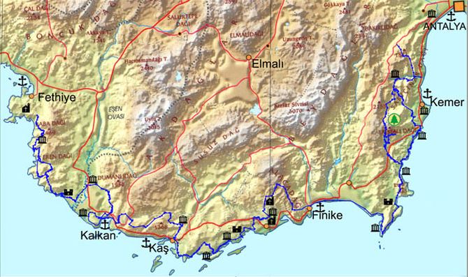
Kumluova-Letoon-Kınık-Ksantos-Çavdır
Before coming to Kumluova, the road goes on through the sandy land covered by eucalyptus trees and shrubberies, then goes on to the left from the location of the fountain. It is not recommended to drink from this fountain. The pathway crosses the bridge after a while and goes on towards the Kumluova – Gerenovası settlements which contain lots of greenhouses. From the road, Letton ruins can be seen. After the Letoon ruins, when going towards east, it goes on until the edge of Eşen River.
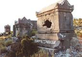
It also goes on to north parallel to Eşen River. Karaköy and from the other side of the bridge Kınık settlements can be seen. This is the first settlement which contains a bank or ATM access from Fethiye on the Lycia road. Across the bridge at the left side, if one goes on upside from the asphalt road from passing in the middle of the bazaar area Xhantos ruins can be seen. After the ruins the pathway goes on parallel to the asphalt road in the forest. Lycia road signs in this area were erased. When you go on to east parallel to the asphalt road, you can see the interurban road intersection.
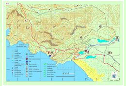
Belcekız – Gavurağılı – Kumluova
The Lycia road splits towards right after a couple of kilometers from the dirt road which splits towards southeast, on a flat area with its red soil, ancient olive trees, carstic limestone and plants indigenous to the Mediterranean seems just like a man made ornamental garden and elevates through high pine trees towards a channel after a region called Belcekız.
After the channel it starts to descend from a steep slope in zigzags. In this region in which the characteristic Lycia road signs are erased, if one goes on to descend from the slope towards southeast, after a while they can reach to the flat areas at the west of the Gavurağılı settlement. A long slope descends ends after passing a stone masonry pathway. The pathway which goes on for one km among the trees and fields, reaches to Gavurağılı settlement.
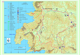
Gey – Bel ; Boğaziçi – Sidyma
In the Alınca settlement the pathway of Lycia road which is separated from the asphalt road, goes towards south along the slope overlooking the sea at the west side of the Eren Mountain. The pathway going downwards from the Üçkeçi region in which there are bee hives to Cennet Bay, separates from the Lycia road. The pathway which goes on towards south for a while, reaches to a flat valley on which there are stone terraces on some parts.
One can reach to Pirate bay with the pathway separating towards right after the first cistern to be seen here. Along the Pirate bay and the cape located in south Kalabantia archaeological settlement can be seen. If one goes on from the marked Lycia road without leaving, this Lycia road splits into two before a village home, and at the right side it goes on from Gey and Yediburunlar towards Bel settlement.
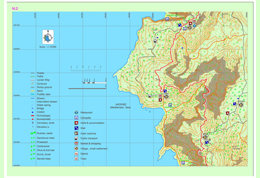
Faralya – Kabak- Alınca
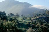
The Lycia road which goes on downward from Kirme settlement, reaches to the asphalt road of Faralya settlement after passing near large and small water sources. Faralya village settlement is located at a very special location in terms of flora, on a slope overlooking the south at the mountainside of Babadağ and just above the valley of butterflies. It contains most endemic plant types.
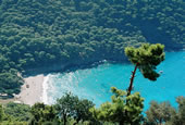
The minibus coming from Ölüdeniz, reaches to Uzunyurt or even Kabak settlements after passing from Faralya. At Faralya there is a market and shopping opportunity. Accommodation in camp, bungalow and Mediterranean type hotels made from stone is available. Before passing Faralya if you turn towards right from the main road, the peerless view of the valley of the butterflies can be seen. There is even a pathway reaching to the camp site located down at the valley downwards from this turn. The descent is made by hanging to the ropes set on crags. This is extremely dangerous for the people with heavy loads and amateur walkers.
Subcategories
Accommodation Article Count: 0
Tours & Activities Article Count: 1
Tours, trips Article Count: 1
Boat Tours Article Count: 0
Trekking Article Count: 0
Blue Cruise Article Count: 0
Discover Lycian Article Count: 34
|
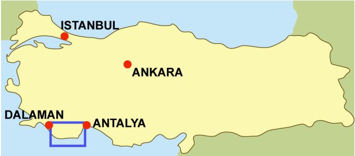
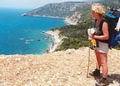
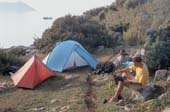
The Lycian way is a 509 km way-marked footpath around the coast of Lycia in southern Turkey, from Fethiye to Antalya. The Lycian Way is a coastal walk and mild temperatures mean it can be walked throughout the winter months. According to the Sunday Times the Lycian Way is one of the ten most beautiful long distance hikes of the world. The route is graded medium to hard; it is not level walking, but has many ascents and descents as it approaches and veers away from the sea. It is easier at the start near Fethiye and gets more difficult as it progresses. We recommend walking the route in spring or autumn; February-May or September-November; summer in Lycia is hot, although you could walk short, shady sections. The route is mainly over footpaths and mule trails; it is mostly over limestone and often hard and stony underfoot. On the first part of the route, and in Patara, Kalkan, Kas, Myra, Finike, Adrasan, Olympos, Cirali and Tekirova, you can stay in pensions or small hotels. On other nights, you may stay in a village house, or camp out. There are plenty of camping places with nearby water mentioned in the book; you do not have to ask permission to camp out.
Highlights of the Lycian Way include: |
|
Lycian Way Article Count: 31
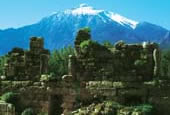
| Teke peninsula, which is located between the Antalya and Fethiye gulfs in the Mediterranean region, was named as Lycia in ancient geography. The southern border of the region is its coast to the Mediterranean Sea, while its eastern, western and northern borders changed throughout the history. According to the ancient writers, Beydağları which start from the west of Antalya and extend to southwest, Akdağ range and their extension to the northwest defines the northern border of Lycia. In the famous epic poem Iliad, Homer states that the Lycians, which were commanded by Glaucus and Sarpedon, supported the Trojans against the Achaeans. |
Lycia came under the dominance of the Persians after 545 BC and supported the fleet that was formed by the Persian King Xerxes for the conquest of Greece in 480 with 50 ships. The Persian occupation ended when Alexander the Great crossed the Bosphorus to Anatolia and defeated the Persians in 333 BC in the Battle of Granicus. After the death of Alexander the Great, Lycia came under the dominance of Ptolemaic dynasty in Egypt, which descended from the general Ptolemy, from the year 309 BC for 100 years; this is known to be the period in which Lycian language was forgotten and replaced with Ancient Greek.
The region has been ruled by the Syrian King Antiochus III between the years of 197 BC and 167 BC. Lycia received its independence from the Roman Empire in 167 BC. During this period, 23 cities united and formed the Lycian League, of which the capital city was Xanthos. According to inscriptions and ancient coins the League had its monetary unit.
Strabo states that the six biggest cities of the Lycian League were Xanthos, Patara, Pinara, Olympus, Myra and Tlos. The Miliarium Lyciae, which is the map of the Lycian region with distance units and routes connecting the settlements, is the oldest road map known. During the Roman Empire period, the League did not lose its function and reached maximum level of prosperity during this time. The city populations were around 5,000 and the total population of the region was approximately 200,000. The borders were pushed further as to include Kaunos (Dalyan) in the northeast.
Around the middle of 5th century, there were 34 cities ruled by the Proconsul of the Lycian State. The region between Demre and Kaş was the most populated area in Lycia. The amount of settlements per kilometer is nearly 30 in this region. Introduction of Christianity to Lycians did not occur until the visit of St. Paulus to Myra and Patara at his third missionary journey between the years of 53 and 57. Methodius of Olympus was the first known bishop of Lycia and he was executed in 312. The Byzantine period between 4th and 7th centuries was the period in which Christianity was adopted and many churches were built in the region.
One of the most prominent changes that occurred during the said period was the start of monastery settlement constructions, especially in the mountainous areas of Demre. Monasteries were very important points of power which had influence on the economic and public life. The monastery life in Lycia started as early as the 5th century. The fact that many large churches were built during the 5th and 6th centuries indicates that the population of the region was very high during the said period.
Most of the Lycian coast is formed of rocky terrain. This type of topography has allowed for natural harbors to be shaped at some locations. Strabo has expressed that the Lycian coastline is rough and difficult to pass through, while the harbor is very well-equipped. Maritime trade, which existed in the region since the Bronze Age, became diversified in the following periods and lasted until the Roman and Byzantine Periods. Purple dye, cedar wood, olive oil, wine and sponges are the key goods that are produced in Lycia. According to ancient sources, high quality and soft sponges can be harvested at Antiphellus and the area surrounding it. In addition, the quality of the cedar wood in Lycia, which is used in shipbuilding is rather high as well.
The harbors in Lycia can be named as Idyros, Phaselis, Corycus, Olympus, Posidarisus, Melanippion, Gagae, Phoinikos, Andriaca, Simena, Teimussa, Aperlae, Antiphellus, Kalamaki, Phoinike, Patara, Pydnai, Arymnessos/Perdicia, Calabantia, Karmylassos, Telmessus, Krya, Lisse and Lydai, respectively from east to west.
Of these harbors, Andriaca and Patara is distinguished from the others in that they possess political and economic power, in addition to being an internationals trade point. By virtue of its local traditions and distinctive architectural style, the region is the most interesting area in Anatolia; the cities of the region are generally located on the coasts and the valleys of Xanthos and Arycandus, which are considered to be the core of the region. Some of the texts that belong to the Lycians, who were known for having their own language and alphabet, were translated into modern languages; most of these are epitaphs.
The region of Lycia consists of cities of large, medium and small scale, port cities, military zones, farm settlements and towers. Most of the visible remains in the region belong to the Roman and Byzantine periods. The most encountered types of remains in the traditional settlements concentrated in the mountains are olive oil and wine workshops, and agricultural terraces. These rural settlements, in which most of the population lived, provided food for both themselves and the large cities.
The residential structures in Lycia are generally divided into four groups. The first group consists of adjacent residences in which each room has its own entrance. The second group is made up of stand-alone residences of one or two rooms in rural settlements. Both types of residences in these groups are generally two-storey houses that are located collectively or closely within walls of the settlement. The third group consists of single-storey residences with two to four rooms in agricultural areas of which some has courtyards, cisterns and workshops, while the fourth group is made up of residences of mostly rich people in rural areas, which are built as rooms surrounding a courtyard which is positioned in the middle.
Natural disasters and epidemics that occurred in the region have deeply affected the lives of those in the cities. The most prominent of these are the earthquakes that occurred in the years 141, 240, 385, and 529, and the plagues that happened in the year 542 and the period between 1346 and 1347. Due to the blights that were suffered in the coastal regions, the settlements in the inland areas came into prominence. Emperor Constans II fought the Arabians in 655 on the coast of Phoenix with the fleet he personally commanded. After being defeated, the Emperor managed to survive by way of the self-sacrifice of a young soldier. After this battle, the Arabians began navigating freely near the Mediterranean coasts.
In 802, the regions of Lycia and Caria were occupied by the Abbasids. During the 10th century, Lycia and the whole of the Mediterranean region were under the domination of the Byzantine Empire. Turks acquired access to Lycia after the Seljukian Sultan Kılıç Arslan II defeated the Byzantine army. After 1204, the whole of Lycia came under the domination of Turks.
Mountainbike tours Article Count: 1
Vacation Spots Article Count: 37
Kaş Article Count: 7
Olympos/Çıralı Article Count: 6
Kalkan Article Count: 6
Patara Article Count: 6
Kekova Article Count: 6
Demre/Hoyran Article Count: 6
Demre/Hoyran